Starting to Heat Up
Skipping forward 100 million years, the supercontinent of Gondwanaland was now drifting slowly across the southern polar region and the land was covered with thick ice sheets. The grooves scoured out by these glaciers can still be seen at Grasdrift, close to the Richtersveld National Park, and at Nieuwoudtville.

By 270 million years ago, however, the land had moved out of the polar region and things were starting to heat up. Accordingly, the glaciers began melting, leaving behind glacial deposits that became the Dwyka group of tillites.
This marks the start of the Karoo Supergroup, which extends over much of South Africa’s current interior. These deposits are distributed unevenly in the Namaqualand region, lying on top of the Nama Group of rocks.
Geological Turbulence

Around the same time as the Dwyka deposition, the entire region was subject to an extended period of geological turbulence, when Gondwanaland started splitting apart into what are now the South American and African continental landmasses.
This caused dramatic folding of the rock layers and considerable orogenic (mountain building) activity across the region. As part of this upheaval, a large basin was formed across the Karoo region and the south-eastern parts of Namaqualand. The Ecca and Beaufort groups were subsequently deposited into this basin, forming the basement of much of the Nama-Karoo biome.
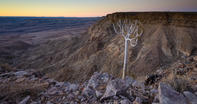
As part of this process, the sea level also receded to expose the coastal plains, and rivers running down to the new coastline proceeded to erode the uplifted plains. This caused, amongst other things, the formation of the Fish River Canyon (2nd largest on Earth, after the Grand Canyon in North America). By this time, the Namaqualand region was already quite dry and the newly exposed marine terraces began to get covered by sandy deposits.
Quantities of Diamonds

The next important phase occurred around 120 million years ago, when a series of volcanic pipes pushed their way up from the Mantle towards the surface. These funnel-shaped pipes carried with them considerable quantities of diamonds, formed at a depth of up to 250 km below the surface.
The gems were encased in a special kind of crumbly rock called Kimberlite. Over the millennia that followed, these diamondiferous pipes were subsequently eroded by rivers (most notably the Orange River) and the glittering wealth was washed away towards the Atlantic.
The diamonds were thus deposited along the banks of the Orange and at the river’s mouth, with the thickest layer of diamondiferous gravel being laid down between 20 and 15 million years ago.
By 100 million years ago, South America and Antarctica had separated from the African landmass and the African subcontinent (which had once been in the centre of the Gondwana supercontinent) was surrounded by water.
This caused the rim of the subcontinent to ‘buckle’, resulting in the creation of a low-lying coastal plain that was separated from the high interior plateau by a sharp ‘escarpment’.
Major Watercourse Region

By now, the river that would become the Orange (or !Gariep) was already the major watercourse in the region. It originated in the highlands of Lesotho and flowed in a westerly direction to enter the Atlantic Ocean near present-day Alexander Bay.
Then, around 65 million years ago, a little geological hiccup caused the Orange to change its course. It subsequently shifted to the south and ran through the Koa Valley to reach the Atlantic near the mouth of the present-day Olifants River. This meant that millions of tons of diamond-bearing gravel were now getting washed into the sea, only to be transported up the coast by the nascent, north-flowing Benguela current.
50 million years later, however, another subterranean glitch caused the Orange to revert to its original course through the Richtersveld to Alexander Bay. The result of all this to-ing and fro-ing is that the entire north-western coast of South Africa, as well as the southern coast of Namibia, is laden with diamonds.
Moving right along, the western coast of South Africa grew steadily drier over the next couple of million years. The Namib desert, one of the world’s oldest, was thus established between 40 million and 25 million years ago.
Finally, by 5 million years ago, the cold Benguela current (which originates in the Antarctic) had become the dominant climatic factor in this arid region. This coincides with a climatic change which saw Namaqualand shift from a summer rainfall area to a winter rainfall area.
Namaqualand Coastal Plain
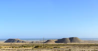
The last major geological development started around 5 million years ago, when the Namaqualand coastal plain was uplifted. This exposed several marine terraces that were gradually covered by a variety of sand types. Mixed in with the sand, however, were millions of those gem quality diamonds we mentioned above, and these gravel beds are being voraciously mined today.
We should also note that the marine deposits which remain underwater also contain diamonds, and these are being exploited by diamond boats which suck up the valuable sand and transport it to on-shore sorting facilities.
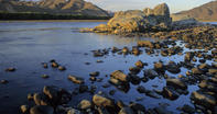
One last thing to mention: the most recent rocks in the region are found along the banks of the Orange River where thick layers of silt have accumulated as a result of flooding. Some of these banks are 30m higher than the current water level, signifying the biggest floods in southern Africa. Dating of these rocks has shown that some of these floods took place a mere 700 years ago, which suggests that they could occur again!
Land of Contrasts
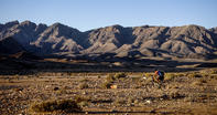
The landscape we see today: a rugged, cold shoreline with a wide, sandy coastal plain separated from a hot, dry interior by several ranges of jagged mountains. It is indeed a strange land of contrasts, resting on a jumble of volcanic, igneous, sedimentary and metamorphic rock formations.
As Francois Odendaal and Helen Suich write in their book on the Richtersveld, “There are few places in South Africa where such a large number of geological units are visible, and it is partly this diverse range of rock types, as well as their varied elevations, that creates the variety of habitats in the Richtersveld, which in turn makes it possible for such a high plant diversity to evolve".
By David Fleminger