Montagu Pass

Charles Michell, chief engineer at the Cape, was a persistent campaigner for better roads in the colony. Luckily, the head of the newly formed Central Road Board, John Montagu, was in complete agreement. Their first joint venture was to be Montagu Pass, from George to Oudtshoorn.
Montagu Pass was opened with great fanfare and to universal acclaim. It was comfortable, well surfaced, and the steepest section only had a gradient of 1:6. It was a pass that could be safely travelled by any wagon, over and over again. Everyone considered it £35 000 well spent.
The remarkable thing is that, 150 years after it was built, the old, gravel road is still open to traffic. And it hasn’t changed a bit, making it the oldest unaltered mountain pass in South Africa. This has earned Montagu Pass the well-deserved status of a national monument.
Historically, Montagu Pass is very rich, and the various well-tended signposts give you real flavour of the old days. ‘Die Noute’ is the narrowest part of the pass, and ‘Regop Trek’ is a slightly exaggerated name given to the steepest section of the road.
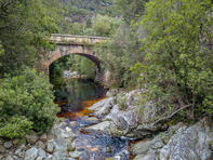
Montagu Pass also has two other national monuments along its course: The Keur River Bridge, a rustic stone archway built by Michell, and the ruins of the Old Smithy. Both are signposted and the bridge is quaintly attractive.
Robinson Pass
Mossel Bay was once the coastal terminus of the Eastern Highway before the road headed north over Attaquas Kloof. In 1848, Montagu Pass opened, and traffic quickly adopted the neatly engineered road as opposed to the rough elephant track that was Attaquas. This meant that, although it was still the main port of the region, Mossel Bay was somewhat cut out of the loop. The town’s fathers scrambled into action, looking to find a replacement for the crumbling Attaquas Kloof route.
They finally identified a likely bridle path, called Ruytersbosch Pad, just East of Attaquas Kloof. The Mossel Bay Divisional Council committed some money and, after much nagging, the government agreed to share the expense. But, despite this spirit of co-operation, the first attempt to build a pass quickly failed. Enter Thomas Bain. In 1867, fresh from his efforts on the Prince Alfred Pass near Knysna, Bain was sent to Mossel Bay to create an alternative to Attaquas Kloof. The Robinson Pass was opened in 1869, named after some arbitrary Inspector of Public Works, and was tarred in the early 1960s.
Outeniqua Pass

The first motor cars in the George area of the Western Cape appeared around the turn of the 20th century and their numbers steadily grew over the years. So, when the first national road plan was being drawn up in the 1930s, it became apparent that the old Montagu Pass, which had carried animal-powered traffic for 80 years, could not be upgraded to modern specifications.
Legendary road engineer, P.A. de Villiers, looked at many alternative routes, and finally planned a brand new pass which would carry motor cars safely over the Outeniquas. Construction began in 1942, during the Second World War, when several hundred Italian prisoners of war (POWs) were conscripted from the Cape and put to work.
The wide carriageway required rock cuts 20 m deep and fills more than 30 m high. The reluctant Italian labour-force, understandably, was not entirely up to the task and, when the war ended, the Italians happily went home, having completed only one-tenth of the pass. A few hundred local ‘African’ workers were then sent for, and got on with the job. The pass was opened in 1951.
By 1990, the lack of passing lanes had made progress down the pass frustrating. Long queues snaked behind the slow-moving trucks, and impatient drivers diced with death each time they tried to overtake on blind corners. It’s particularly worth stopping at the 4 Passes view site, from where you can see the white stones marking the original Cradock Kloof Pass, the brown scars of Montagu Pass and the railway pass, all snaking up the opposite side of the Y-shaped valley.
Prince Alfred’s Pass

Sometimes called the granddaddy of the Cape’s mountain passes, Prince Alfred is certainly a long and confident access route. Originally intended to help people get in and out of Knysna, Prince Alfred. It opened in 1868 and was named after Queen Victoria’s son, who was in South Africa for an elephant hunt. Prince Alfred is a very long pass, about 70 km from beginning to end, and it leads through some exquisite scenery. The first half of the road had to be hewn out of the dense forests around Knysna, and this part of the road still runs through indigenous woods, which contain hiking trails and cycle paths beneath their leafy bowers.
About 40 km from Knysna, the road hits a junction. If you turn right, you will travel over the gravel Gates of Eden Pass and down to the N2, a few dozen kilometres outside Plett. This route used to be called Paardekop, and was part of the old road from Plett to George. If you keep going straight, you will head up towards the main section of the Prince Alfred Pass. Once clear of the forests, the pass finally begins its ascent up the flanks of the Outeniquas. It is a memorable drive, as the gravel road gently curves up the wall of a vast, green amphitheatre, before finally cresting the mountains and entering the Klein Karoo near the town of Avontuur.
Bains’ Kloof
Trivial Pursuit question: what is the only road in South Africa that is a national heritage site? This is a nasty one, because so many could, and should, be, but only Bain's Kloof is. Bain’s Kloof runs through the Slanghoek Mountains between Wellington and Tulbagh Valley. It was built not by the better-known engineer of the building dynasty, Thomas Geddes, but by his father, Andrew — his good old dry-stone-wall-packing self.
Once over the mountains and Tulbagh valley, you can have tea at the old toll house at the base of Michell’s Pass. This latter pass is not much of a challenge anymore, but the route is older than that of Bain's Kloof and was once the main way north to the Karoo and its diamond fields. Bain's Kloof Lodge is a great stopover, exactly of the kind you can expect to find only when you are not expecting anything.